Varsity View & Princeton Manor
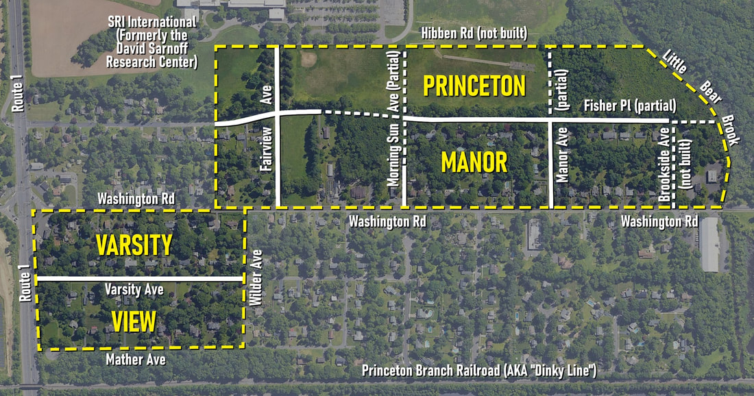
Original planned boundaries of Varsity View and Princeton Manor. Not all roads were built.
Historical Overview
|
Until the 1920s, the historic West Windsor community of Penns Neck was a lightly-populated farming community. However, that decade, two suburban communities - "Varsity View" and "Princeton Manor" - were at the forefront Penns Neck's long march toward suburbanization.
By the 1926, Julius C. Wildermuth had acquired enough land to present plans for "Varsity View" - a community of 42 lots Route 1, Washington Road, and the Princeton Branch Railroad/Dinky Line.[1] The tract included three new streets: Varsity Avenue (named after the development and capitalizing on its branding as "Princeton's most convenient suburb"[2]), Wilder Avenue (presumably named after Wildermuth himself), and Mather Avenue (named after the Mather family, who had owned a local farm).[3],[4] Advertisements also boasted about "excellent water, electricity, gas, and sidewalks," a "fine Public School," and "Trenton and Princeton Bus Service." All lots were restricted for residential use only, although the Penns Neck Community Club along Route 1, and an eventual gas station at the southeastern corner of the intersection of Route 1 and Washington Road, broke this mold.[5] |
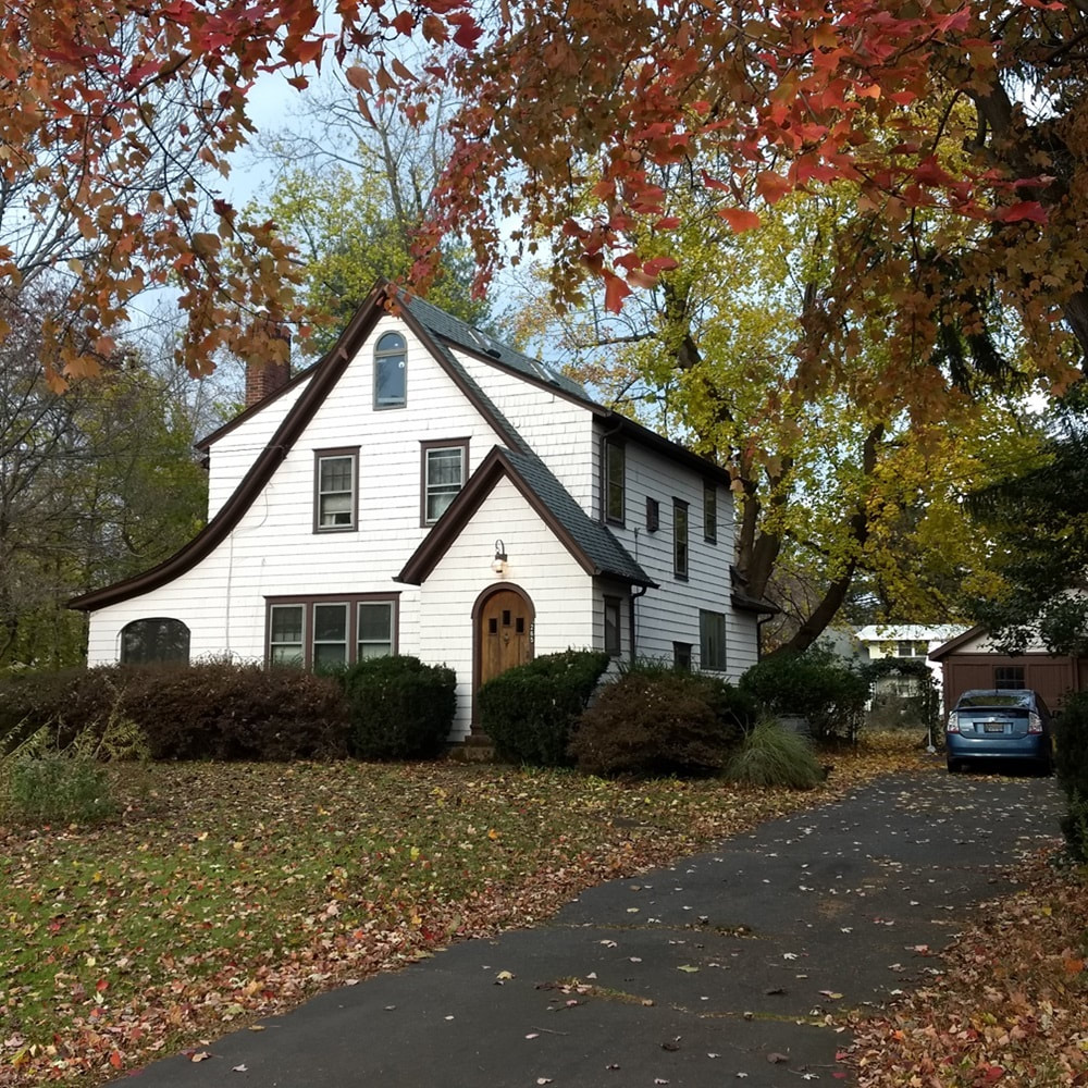
Varsity View house at 265 Varsity Avenue.
|
|
In 1927, Fred T. Walters presented plans for "Princeton Manor." This development was significantly bigger than Varsity View, with 150 mostly-uniform lots planned north of Washington Road, between the Little Bear Brook and Route 1. New planned roads included evocative names such as Manor Avenue, Brookside Avenue, Morning Sun Avenue, Fairview Avenue, and Hibben Place.[6] All but Brookside and Hibben were constructed; in fact, the entire northern row of 34 lots were never developed and instead eventually became part of the old David Sarnoff Research Center complex.[7] Unlike Varsity View, no restriction on development type in Princeton Manor is known - hence the presence of local landmarks like DeSautelle's plant and flower shop, the Bear Brook Tavern, and Jerab's Market.
In both Varsity View and Princeton Manor, buyers often purchased empty lots and constructed their own homes. Some of these houses are identical in form, suggesting similar builders.[8] Julius Wildermuth himself is said to have been a master carpenter who constructed several homes. Other houses are said to have been assembled from kits provided by Sears and other companies.[9] This mirrors the nature of the community of Berrien City, which itself was begun south of the Princeton Junction train station in the 1910s.[10] Early families in Varsity View and Princeton Manor included the Engelkes,[11] Applegates,[12] Mahers,[13] Jerabs,[14] DeZwarts,[15] and Warrens,[16] among others. Homeowners continued to move into Varsity View and Princeton Manor over the ensuing decades, growing both developments. Today, many dozens of homes front tree-lined streets established generations ago during Penns Neck's early years of suburban growth. |
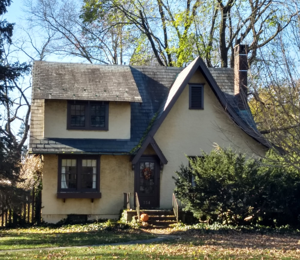
Varsity View bungalow at 254 Washington Road, Nov. 2018.
|
Historical Varsity View & Princeton Manor Homes
Click on each of the images below to learn more about some older Varsity View and Princeton Manor landmarks! As of now, the list below contains only homes we believe to be 100 years or older. Research is ongoing so if you would like us to add your home, please contact us.


Bibliography
- Wildermuth, Julius. “Varsity View.” Map. Mercer County Clerk’s Office Map Collection. Princeton, New Jersey: Sincerbeaux & Moore, Civil Engineers, 1926. Map No. 517 in the Mercer County Clerk's Office map collection.
- J. C. Wildermuth. (1925, July 5). Build a Home at "Varsity View". Trenton Sunday Advertiser. Trenton.
- Mather Farm. Photograph. West Windsor, NJ, n.d. West Windsor History Museum. Probably from late 1800s or early 1900s. Shows Mather Farm in Penns Neck.
- Wildermuth, Julius. “Varsity View.” Map. Mercer County Clerk’s Office Map Collection. Princeton, New Jersey: Sincerbeaux & Moore, Civil Engineers, 1926. Map No. 517 in the Mercer County Clerk's Office map collection.
- J. C. Wildermuth. (1925, July 5). Build a Home at "Varsity View". Trenton Sunday Advertiser. Trenton.
- Walters, Fred T. “Princeton Manor.” Map. Mercer County Clerk’s Office Map Collection. Princeton, New Jersey: Sincerbeaux & Moore, Civil Engineers, 1927. Map No. 522 in the Mercer County Clerk's Office map collection.
- "West Windsor Aerial Photography Composite Map, 2023.” Map. Historical Society of West Windsor - Map Archives. West Windsor, NJ, 2023.
- Personal observations of this article's author - Paul Ligeti.
- Ligeti, Paul T. I., and Parris, David and Parris, Susan. Interview with Susan and David Parris. Personal, 2020. Note: Susan and David have lived in Penns Neck since the mid-1900s and have personally known many of the people who lived in the village.
- Sincerbeaux, C. S. “Map Showing Plan of Lots for Scott Berrien Esq.” Map. West Windsor, New Jersey, 1916.
- "Princeton Manor Building Lot Sold." Trenton Sunday Times-Advertiser. February 20, 1927.
- "Lot is Purchased." Trenton Sunday Times-Advertiser. December 19, 1926.
- "Princeton Manor Sale." Trenton Sunday Times-Advertiser. March 29, 1927.
- "Princeton Manor Lots Are Selected." Trenton Sunday Times-Advertiser. July 3, 1927.
- "Princeton Manor Sale." Trenton Sunday Times-Advertiser. September 11, 1927.
- "Walters Sells Lots." Trenton Sunday Times-Advertiser. November 27, 1927.f

